
 |
| The highest point en route - Mt Luxmore. |
 |
| Still bright and shiny at the start of the hike. |
It is exactly two years since our last multi-day hike/tramp. And to top it off, we haven't been very active on the running front over the last year or so either. But we thought this hike would be a nice way to end the year and hopefully entice some new years resolutions on the active front.
 |
| Gerry crossing the Waiau River at the start. |
We chose this hike for a number of reasons: it is a circular route which means we don't need to arrange transport to or from the start or finish; and the route seems to be fairly easy, which is almost a prerequisite in my unfit state.
We were also keen to visit the South Island again, and this hike is as south as it gets. Almost. The Kepler Track is one of the Great Walks of NZ. The start and finish are at Te Anau, a tiny town next to Lake Te Anau, which is the second-largest lake by surface area in NZ (after Lake Taupo) and the largest in the South Island. Lake Te Anau is the largest lake in Australasia by fresh water volume.
 |
| Lovely to walk in the shade of beech, kamati and podocarps. |
 |
| Lake Te Anau in the back. We stopped for a quick lunch in the shade - hence the "shady" photo. |
By 9:00 in the morning we were packed and parked and ready to go. We started at the Rainbow Reach car park and after about 15 minutes of walking, Gerry suddenly realized that we forgot to take identification with us. So he left his pack next to the track to walk back for our drivers licences. A couple of minutes after he left, I realized with a shock that I hid the wallet and he might not find it. So off came my pack and I started running back, only to reach him already returning from the car having found the wallet. He knows me so well! So maybe that was the beginning of my new running resolutions for 2013. :-)
 |
| Tent pitched, fire going and a tipple in the cup. What more could a girl ask for. |
After an hour or so of walking, I noticed a bright purple "bottle cap", but when trying to scrape it from the undergrowth with my shoe, I discovered it was a mushroom! What an unusual looking mushroom and I instantly felt sorry and guilty for killing the beautiful toad stool.
After passing the Kepler car park, the commercial side of things became more evident. Boats, wet-bikes and skiers were hoarding the lake noisily while the number of day walkers also increased.
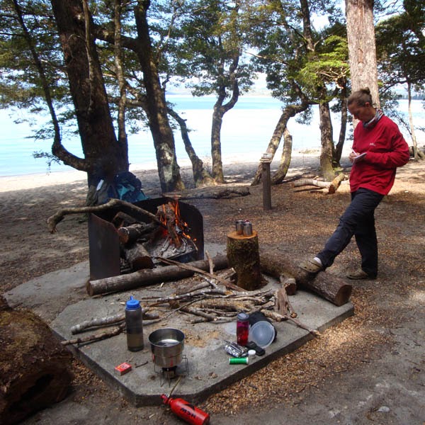
The overnight spot at Brod Bay is a lovely camp right next to the lake with a shelter for cooking, a rainwater tank and two long-drops. We arrived shortly after two in the afternoon and apart from the water taxi picking up day trampers, we seemed to be the only campers.
We dropped our packs to admire the view when next moment we were completely covered in a gazillion sandflies and with a shock realized that we had nothing to repel the biting, gnawing and irritating little bastards.
 |
| Evidence of sandfly havoc when skin is exposed for just a short while. |
In the hope that a fire and some smoke would deter them, we built a big campfire. But alas, it didn't help. We pitched the tent, poured a tipple, made some cup'o'soup and spent a lazy afternoon in the sun, watching time go by. The last batch of day hikers we saw, gave us their citronella ointment for the hike - kind folk from Coromandel, but the sandflies don't seem to be too fazed by it.
By six things started to quiet down on the water and we had a bit of a washup in the lake. On the far side of the lake, Te Anau was still soaking up the sun with tiny slithers of snow on the mountains in the back.
For sustenance we had pasta and sauce with dried veggies.
For sustenance we had pasta and sauce with dried veggies.
In the morning, more blue skies without so much as a breeze, greeted us. In an attempt to avoid the sandflies and mozzies, we jumped out of the tent and packed up as quickly as possible, and were on our way by seven. Mozzies joined the sandfly party during the night and the tent underneath the flysheet was packed with zzzing little insects.
Day two was going to be the toughest on our route, gaining about 1.4km in altitude, only to descend again to about 500m above sea level to reach our next stop over, about 23km later. Almost from the moment we sat foot outside the tent, we were going uphill at a steady pace. We decided to go "pule-pule" (slowly-slowly), Kilimanjaro style, to preserve some energy for later in the day.
It took about two hours to reach the limestone bluffs - a very impressive rock formation. All along we were walking in beech forest with solid green undergrowth. Although it is very hot the shade of the trees makes for a very pleasant walk. Shortly after we reached the tree line, a blazing sun was beating down our necks. Luckily and maybe because of the remaining bits of snow that was still visible on the mountain, the ambient temperature was on the cool side.
 |
| Sunny and very hot once we reached the tree line, unsheltered from the tree canopy. |
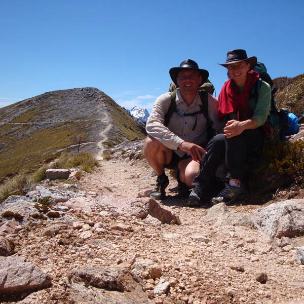
But what a wonderful view we had walking on top of the mountain ridge. After 3 and a half hours, we reached the Luxmore Hut. Leaving our packs to explore the caves that are a 10 minute walk from the hut, we realised that our torches weren't really up to the task. We will definitely be better prepared next time.
We filled our water bottles and by 11:00 we left the hut to follow the ever upwards rocky path. Up and up we went, while the temperature felt deceivingly cooler than what it actually was. As a result we didn't drink enough water and dehydrated a little, luckily only enough for some minor headaches.
At around 12:30 we reached the highest point on the route, sitting next to the beacon on Mt Luxmore. What a magnificent view. Glorious vistas over the Jackson Peaks, Kepler Mountains, Murchison Mountain and Lake Te Anau. And with blue skies and no wind, we could not have asked for a better day.
25 December (22.6km) - Iris Burn Hutt to Rainbow Reach car park
We aimed to get an early start again and because of the sandflies we managed to pack up nearly everything while still inside the tent. Shortly before seven, we jumped out, (or in my case, rather crawled out), packed the tent to discover two little father Xmas chocolates under our tent flap. That truly got us into the Christmas spirit and every time we encountered someone on the route, "merry xmas" was the first words everybody uttered.
The last day's walk is mainly flat, with a slight downhill. My descending muscles were completely buggered, which made the going very tough. We started off with a bit of a climb, but mainly strolled thought the beech forest. A lovely, mostly flat walk next to the Iris Burn River takes you past a work camp for track maintenance, a large slip, through a bog, past Rocky Point shelter and through a gorge. We reached Moturau Hut by the lunch time, which is situated next to Lake Manapuri. The biggest uphill section is a detour from the original path with very steep swithsbacks downhill to get back onto the track.
We filled our waterbottles at the hut and had a bit of a chat to the ranger. Some of the other hikers were taking a dip in the lake, but the water was just too cold for me - guess I really do need to toughen-up a bit!
Walking under the trees were so nice after the long day in the blazing sun. And I was lucky to spot another one of the purple mushrooms! After a long section next to the lake, the path veers to the left, passing through a wetland until you finally reach the Waiau River again to walk the final section back to the Rainbow Reach car park. We reached the car park by 3 in the afternoon and went scouting for a shower. But with it being Xmas day and all, not much were open in Te Anau, so we drove up to Queenstown where we found a campsite just north of the town for the night. Pitched the tent by 8 and celebrated Xmas and our great adventure with dry bread, baked beans and warm wine that we had in the car, feeling happy on an endorphin high.
Hope to spend another Xmas in the mountains next year.
We filled our water bottles and by 11:00 we left the hut to follow the ever upwards rocky path. Up and up we went, while the temperature felt deceivingly cooler than what it actually was. As a result we didn't drink enough water and dehydrated a little, luckily only enough for some minor headaches.
At around 12:30 we reached the highest point on the route, sitting next to the beacon on Mt Luxmore. What a magnificent view. Glorious vistas over the Jackson Peaks, Kepler Mountains, Murchison Mountain and Lake Te Anau. And with blue skies and no wind, we could not have asked for a better day.
 |
| Leaving our packs in the path to climb the last bit to the top of Mt Luxmore. |
 |
| There must be millions of similar pics out there - doing the touristy thing and get your photo taken by a fellow hiker at the beacon. |
 |
| Lonely in the saddle since my horse died. |
 |
| For miles and miles the path meanders on the ridge with magnificent views to both sides. |
 |
| Taking a little break in the mid-day sun. |
 |
| One of the two shelters on top of the mountain. This one being Hanging Valley Shelter. |
We stayed a little, took some photographs, chatted to people and then started the descent via the saddle of the mountain, counting our lucky stars that we had no wind. I cannot imagine how scary it must be in gusty conditions.
We reached the first shelter where we stopped for lunch. A few more saddle crossings and another bit of a climb, takes you to the second shelter. And from there it is downhill all the way. Once you reach the treeline, switchbacks makes for a fairly steep descent.
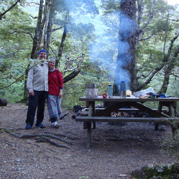
We reached Iris Burn Hut at about seven that evening, pitched the tent and started the camp stove for boiling water. Nothing like a nice cup of soup at the end of a hard day in the mountains. We washed in the stream, made a fire and poured a tipple. It is Xmas eve after all, and some of the other hikers donned reindeer antlers and father Xmas hats, tinsel etc to get into the spirit of Christmas.
Millions and millions of sandflies were on their post again, trying to spoil a perfectly nice evening next to a campfire. And for the most of it, they succeeded. I'll be sure to go as chemical as possible next time to deter the little buggers.
We cooked pasta and tuna for dinner before diving into the tent. Happy to be safe and sound in our sleeping bags, we listening to moreporks calling while drifting off into dreamland.
We reached the first shelter where we stopped for lunch. A few more saddle crossings and another bit of a climb, takes you to the second shelter. And from there it is downhill all the way. Once you reach the treeline, switchbacks makes for a fairly steep descent.
We reached Iris Burn Hut at about seven that evening, pitched the tent and started the camp stove for boiling water. Nothing like a nice cup of soup at the end of a hard day in the mountains. We washed in the stream, made a fire and poured a tipple. It is Xmas eve after all, and some of the other hikers donned reindeer antlers and father Xmas hats, tinsel etc to get into the spirit of Christmas.
Millions and millions of sandflies were on their post again, trying to spoil a perfectly nice evening next to a campfire. And for the most of it, they succeeded. I'll be sure to go as chemical as possible next time to deter the little buggers.
We cooked pasta and tuna for dinner before diving into the tent. Happy to be safe and sound in our sleeping bags, we listening to moreporks calling while drifting off into dreamland.
 |
| At our final camp, covering every inch of exposed skin (preferably in more than one layer!) to try and avoid the pesky sandflies. |
25 December (22.6km) - Iris Burn Hutt to Rainbow Reach car park
 |
| Very unusual bright purple mushroom. |
The last day's walk is mainly flat, with a slight downhill. My descending muscles were completely buggered, which made the going very tough. We started off with a bit of a climb, but mainly strolled thought the beech forest. A lovely, mostly flat walk next to the Iris Burn River takes you past a work camp for track maintenance, a large slip, through a bog, past Rocky Point shelter and through a gorge. We reached Moturau Hut by the lunch time, which is situated next to Lake Manapuri. The biggest uphill section is a detour from the original path with very steep swithsbacks downhill to get back onto the track.
We filled our waterbottles at the hut and had a bit of a chat to the ranger. Some of the other hikers were taking a dip in the lake, but the water was just too cold for me - guess I really do need to toughen-up a bit!
Hope to spend another Xmas in the mountains next year.
 |
| Back at the start on Christmas day. Hoping next time we come down this way, we'll the doing the Kepler track trail run. |