Gerry and I have decided to consolidate our running, hiking and other activities into one new streamlined blog called Jog around the Blog, using Wordpress. Dedoorunrun will therefore no longer be updated. Check out our new blog for more regular updates from the slow pokes at the back-of-the-pack. Hope to see you there.
[http://jogaroundtheblog.wordpress.com/]
We are South Africans living in New Zealand since the middle of 2010. I've started this blog to keep track of our running and other activities over here - something for the grandchildren :).
Thursday, November 21, 2013
Monday, October 14, 2013
Kepler Track - 23-25 December 2012
 |
| The highest point en route - Mt Luxmore. |
 |
| Still bright and shiny at the start of the hike. |
It is exactly two years since our last multi-day hike/tramp. And to top it off, we haven't been very active on the running front over the last year or so either. But we thought this hike would be a nice way to end the year and hopefully entice some new years resolutions on the active front.
 |
| Gerry crossing the Waiau River at the start. |
We chose this hike for a number of reasons: it is a circular route which means we don't need to arrange transport to or from the start or finish; and the route seems to be fairly easy, which is almost a prerequisite in my unfit state.
We were also keen to visit the South Island again, and this hike is as south as it gets. Almost. The Kepler Track is one of the Great Walks of NZ. The start and finish are at Te Anau, a tiny town next to Lake Te Anau, which is the second-largest lake by surface area in NZ (after Lake Taupo) and the largest in the South Island. Lake Te Anau is the largest lake in Australasia by fresh water volume.
 |
| Lovely to walk in the shade of beech, kamati and podocarps. |
 |
| Lake Te Anau in the back. We stopped for a quick lunch in the shade - hence the "shady" photo. |
By 9:00 in the morning we were packed and parked and ready to go. We started at the Rainbow Reach car park and after about 15 minutes of walking, Gerry suddenly realized that we forgot to take identification with us. So he left his pack next to the track to walk back for our drivers licences. A couple of minutes after he left, I realized with a shock that I hid the wallet and he might not find it. So off came my pack and I started running back, only to reach him already returning from the car having found the wallet. He knows me so well! So maybe that was the beginning of my new running resolutions for 2013. :-)
 |
| Tent pitched, fire going and a tipple in the cup. What more could a girl ask for. |
After an hour or so of walking, I noticed a bright purple "bottle cap", but when trying to scrape it from the undergrowth with my shoe, I discovered it was a mushroom! What an unusual looking mushroom and I instantly felt sorry and guilty for killing the beautiful toad stool.
After passing the Kepler car park, the commercial side of things became more evident. Boats, wet-bikes and skiers were hoarding the lake noisily while the number of day walkers also increased.
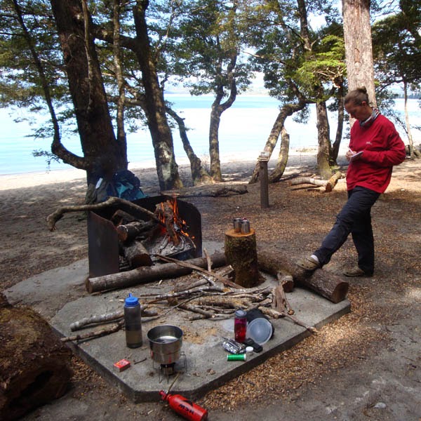
The overnight spot at Brod Bay is a lovely camp right next to the lake with a shelter for cooking, a rainwater tank and two long-drops. We arrived shortly after two in the afternoon and apart from the water taxi picking up day trampers, we seemed to be the only campers.
We dropped our packs to admire the view when next moment we were completely covered in a gazillion sandflies and with a shock realized that we had nothing to repel the biting, gnawing and irritating little bastards.
 |
| Evidence of sandfly havoc when skin is exposed for just a short while. |
In the hope that a fire and some smoke would deter them, we built a big campfire. But alas, it didn't help. We pitched the tent, poured a tipple, made some cup'o'soup and spent a lazy afternoon in the sun, watching time go by. The last batch of day hikers we saw, gave us their citronella ointment for the hike - kind folk from Coromandel, but the sandflies don't seem to be too fazed by it.
By six things started to quiet down on the water and we had a bit of a washup in the lake. On the far side of the lake, Te Anau was still soaking up the sun with tiny slithers of snow on the mountains in the back.
For sustenance we had pasta and sauce with dried veggies.
For sustenance we had pasta and sauce with dried veggies.
In the morning, more blue skies without so much as a breeze, greeted us. In an attempt to avoid the sandflies and mozzies, we jumped out of the tent and packed up as quickly as possible, and were on our way by seven. Mozzies joined the sandfly party during the night and the tent underneath the flysheet was packed with zzzing little insects.
Day two was going to be the toughest on our route, gaining about 1.4km in altitude, only to descend again to about 500m above sea level to reach our next stop over, about 23km later. Almost from the moment we sat foot outside the tent, we were going uphill at a steady pace. We decided to go "pule-pule" (slowly-slowly), Kilimanjaro style, to preserve some energy for later in the day.
It took about two hours to reach the limestone bluffs - a very impressive rock formation. All along we were walking in beech forest with solid green undergrowth. Although it is very hot the shade of the trees makes for a very pleasant walk. Shortly after we reached the tree line, a blazing sun was beating down our necks. Luckily and maybe because of the remaining bits of snow that was still visible on the mountain, the ambient temperature was on the cool side.
 |
| Sunny and very hot once we reached the tree line, unsheltered from the tree canopy. |
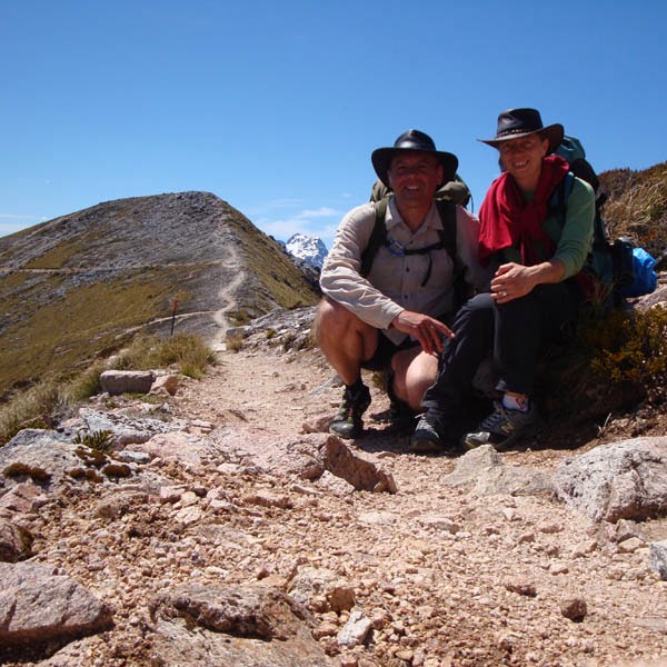
But what a wonderful view we had walking on top of the mountain ridge. After 3 and a half hours, we reached the Luxmore Hut. Leaving our packs to explore the caves that are a 10 minute walk from the hut, we realised that our torches weren't really up to the task. We will definitely be better prepared next time.
We filled our water bottles and by 11:00 we left the hut to follow the ever upwards rocky path. Up and up we went, while the temperature felt deceivingly cooler than what it actually was. As a result we didn't drink enough water and dehydrated a little, luckily only enough for some minor headaches.
At around 12:30 we reached the highest point on the route, sitting next to the beacon on Mt Luxmore. What a magnificent view. Glorious vistas over the Jackson Peaks, Kepler Mountains, Murchison Mountain and Lake Te Anau. And with blue skies and no wind, we could not have asked for a better day.
25 December (22.6km) - Iris Burn Hutt to Rainbow Reach car park
We aimed to get an early start again and because of the sandflies we managed to pack up nearly everything while still inside the tent. Shortly before seven, we jumped out, (or in my case, rather crawled out), packed the tent to discover two little father Xmas chocolates under our tent flap. That truly got us into the Christmas spirit and every time we encountered someone on the route, "merry xmas" was the first words everybody uttered.
The last day's walk is mainly flat, with a slight downhill. My descending muscles were completely buggered, which made the going very tough. We started off with a bit of a climb, but mainly strolled thought the beech forest. A lovely, mostly flat walk next to the Iris Burn River takes you past a work camp for track maintenance, a large slip, through a bog, past Rocky Point shelter and through a gorge. We reached Moturau Hut by the lunch time, which is situated next to Lake Manapuri. The biggest uphill section is a detour from the original path with very steep swithsbacks downhill to get back onto the track.
We filled our waterbottles at the hut and had a bit of a chat to the ranger. Some of the other hikers were taking a dip in the lake, but the water was just too cold for me - guess I really do need to toughen-up a bit!
Walking under the trees were so nice after the long day in the blazing sun. And I was lucky to spot another one of the purple mushrooms! After a long section next to the lake, the path veers to the left, passing through a wetland until you finally reach the Waiau River again to walk the final section back to the Rainbow Reach car park. We reached the car park by 3 in the afternoon and went scouting for a shower. But with it being Xmas day and all, not much were open in Te Anau, so we drove up to Queenstown where we found a campsite just north of the town for the night. Pitched the tent by 8 and celebrated Xmas and our great adventure with dry bread, baked beans and warm wine that we had in the car, feeling happy on an endorphin high.
Hope to spend another Xmas in the mountains next year.
We filled our water bottles and by 11:00 we left the hut to follow the ever upwards rocky path. Up and up we went, while the temperature felt deceivingly cooler than what it actually was. As a result we didn't drink enough water and dehydrated a little, luckily only enough for some minor headaches.
At around 12:30 we reached the highest point on the route, sitting next to the beacon on Mt Luxmore. What a magnificent view. Glorious vistas over the Jackson Peaks, Kepler Mountains, Murchison Mountain and Lake Te Anau. And with blue skies and no wind, we could not have asked for a better day.
 |
| Leaving our packs in the path to climb the last bit to the top of Mt Luxmore. |
 |
| There must be millions of similar pics out there - doing the touristy thing and get your photo taken by a fellow hiker at the beacon. |
 |
| Lonely in the saddle since my horse died. |
 |
| For miles and miles the path meanders on the ridge with magnificent views to both sides. |
 |
| Taking a little break in the mid-day sun. |
 |
| One of the two shelters on top of the mountain. This one being Hanging Valley Shelter. |
We stayed a little, took some photographs, chatted to people and then started the descent via the saddle of the mountain, counting our lucky stars that we had no wind. I cannot imagine how scary it must be in gusty conditions.
We reached the first shelter where we stopped for lunch. A few more saddle crossings and another bit of a climb, takes you to the second shelter. And from there it is downhill all the way. Once you reach the treeline, switchbacks makes for a fairly steep descent.
We reached Iris Burn Hut at about seven that evening, pitched the tent and started the camp stove for boiling water. Nothing like a nice cup of soup at the end of a hard day in the mountains. We washed in the stream, made a fire and poured a tipple. It is Xmas eve after all, and some of the other hikers donned reindeer antlers and father Xmas hats, tinsel etc to get into the spirit of Christmas.
Millions and millions of sandflies were on their post again, trying to spoil a perfectly nice evening next to a campfire. And for the most of it, they succeeded. I'll be sure to go as chemical as possible next time to deter the little buggers.
We cooked pasta and tuna for dinner before diving into the tent. Happy to be safe and sound in our sleeping bags, we listening to moreporks calling while drifting off into dreamland.
 |
| At our final camp, covering every inch of exposed skin (preferably in more than one layer!) to try and avoid the pesky sandflies. |
25 December (22.6km) - Iris Burn Hutt to Rainbow Reach car park
 |
| Very unusual bright purple mushroom. |
The last day's walk is mainly flat, with a slight downhill. My descending muscles were completely buggered, which made the going very tough. We started off with a bit of a climb, but mainly strolled thought the beech forest. A lovely, mostly flat walk next to the Iris Burn River takes you past a work camp for track maintenance, a large slip, through a bog, past Rocky Point shelter and through a gorge. We reached Moturau Hut by the lunch time, which is situated next to Lake Manapuri. The biggest uphill section is a detour from the original path with very steep swithsbacks downhill to get back onto the track.
We filled our waterbottles at the hut and had a bit of a chat to the ranger. Some of the other hikers were taking a dip in the lake, but the water was just too cold for me - guess I really do need to toughen-up a bit!
Hope to spend another Xmas in the mountains next year.
 |
| Back at the start on Christmas day. Hoping next time we come down this way, we'll the doing the Kepler track trail run. |
Saturday, April 28, 2012
Pukeiti Puffer fun run (6-7km) - 1 April 2012
 |
| Gerry, me and Henriette - nervously ready for big things. |
It's been four months since we've done any running. I honestly don't think the four 5km run-walk attempts to try and get us back on the road in February, counts for any level of fitness. I huff and puff pretty much like my mom's bulldog just walking up the 50 metre little incline behind our house!
 |
| Numbered and ready for take-off! |
So when we visited Henriette and Deon in New Plymouth, and Henriette suggested that we do the Pukeiti Puffer fun-run of about 6.5km, my immediate thoughts were "April fools joke! :)". But when I saw that this was no tongue in cheek suggestion, I figured "how hard can it be?". And besides, walking and/or crawling is always an option on such short runs. Maybe this is just what we needed to get us back on the road. Alas, things don't always go according to plan...
Daylight saving kicked in and with the event only starting at 11:15, we had ample time to sleep in, have breakfast and make our way to the venue. A good field of participants pitched for all three events, making parking a wee bit problematic. But we all got sorted and after we entered, the briefing was done before we were off.
 |
| Dark clouds looming just before the start. |
Three different events were presented: a 2km for kids (which I briefly considered when the reality of the "run" finally sunk in), a 6-7km out-and-back run (which we did), and a 10-13km circle loop challenge, which sounded very exiting. If only we hadn't been so lazy the past four months ... As always, the period shortly before any event buzzes with excitement and adrenaline - always a very uplifting moment for me - hyped up and happy to be there, tinted with a little bit of "fear", depending on the size of the challenge.
 |
| And we were off! |
 |
| Me and Henriette, still going strong early in the race. |
It was the perfect day for a trail-run in the park. Overcast and cool which turned into a fairly hot and humid run.
The runners doing the longer event were set off first, and 5 minutes later we were on our way. Starting in front of the lodge, you run across the vast lawn before turning onto the footpath where we reached a nice long downhill, helping us to settle into a slow trot. The "pecking" order was quickly established and we slotted in nicely behind the back runners, just ahead of the walkers.
As we ran the downhill bits (which turned out to be only the first shortish section), we realised that it will all be uphill on our way back! But we decided to just walk all the uphills - there is no way that I would be able to run even three metres uphill in my unfit state.
The trail turned out to be not too technical and really a very lovely run. The Pukeiti Gardens are beautiful and running amongst the trees and shrubs, only surfacing every now and then for a view of Mt Taranaki's foothills, makes for a very pleasant scenic outing.
A hanging bridge at around the 1km mark needs to be negotiated and only four people are allowed on the bridge at one time. That caused a small bottleneck on the way out, but coming back, runners had spread out enough so that this was not a problem anymore.
At about 2kms a watering station manned by friendly helpers provided some much needed H2O. With the humidity and heat, we lost quite a bit of fluid. The last bit of the road before the turn around point, were run (walked in our case) on tar. The biggest part of the first half turned out to be mainly uphill. So you can imagine the fun we had on the way back, as we came screaming down the mountain!
 |
| Queu at the hanging bridge. |
 |
| The marshal at the hanging bridge making sure no more than four people are simultaneously crossing. |
I guess it is thanks to the fun we had, but the course felt a bit shorter than the 6-7km it was supposed to be.
Really glad to have done this, we left for the late brunch and relaxing afternoon at the Roodt's.
 |
| Gerry, on the bridge. |
 |
| A short sealed section at the turn-around point. |
 |
| Too much energy! |
 |
| Henriette on the way back across the bridge. |
 |
| Roll-call at the finish, making sure that everybody made it safely back. |
White Cliffs Walkway - 26 December 2011
Whenever I hear the world "white cliffs", the first thing that jumps to mind, is the brewery. And why not. The White Cliffs Brewery makes a lovely brew.
 |
| Gerry in the blazing hot sun, making his way up the steep climb on private farm roads. |
 |
| Amused cattle with a lovely view from their grazing spot. |
We were visiting in New Plymouth for Xmas when Henriette suggested we do the walk. It is a fairly long hike, 14km point-to-point from Pukearuhe boat ramp to Tongaporutu. So, on the morning of Boxing Day, Deon, Henriette, Gerry and I left for Tongaporutu where we would leave Deon's car at the picnic area next to the Tongaporutu river. On the way back to the start, the four of us were contemplating whether we allowed enough time to complete the walk, having left the house quite late, but we decided to do it anyway.
 |
| Me on a downhill section with Henriette in the back. |
At the beginning of the walkway, a number of routes are available. A short loop track which covers a stretch on the beach, that takes you back to the start, but can only be walked during low-tide. This section can also double up as the start of the point-to-point route which we planned to do. But since it wasn't low tide, we couldn't do the beach section and opted for the inland route higher up. This route follows the Kapuni to Auckland gas pipeline. A third option lets you walk the point-to-point route until about halfway when you reach the Mt Messenger Track, when you make a right turn to exit on State Highway 3.
The first bit, which felt like kilometres on end, is fairly challenging and mainly uphill on private farms. Up and up and up we went in a blazing hot sun and coupled with extreme humidity, it turned out to be a bit more than a casual stroll in the park.
Grazing cows welcomed us as we made our way to the highest point (Parininihi trig) where we could also spot the gas pipeline. Unfortunately the gorse is threatening to take over in places, but otherwise some lovely indigenous forest provided much needed shelter from the sun.
At about 4 kms, when looking back on the route, you could see the white cliffs that provided the name.
 |
| Deon, Henriette and Gerry in front. Evidence of strong winds can be seen by die angle of the tree on the hill. |
At around the 6 km mark, Te Horo Stock tunnel takes you down to the beach, but this section has unfortunately been closed in recent years due to erosion and lack of maintenance. The tunnel is unstable and dangerous to use. Pity though as this would add something special to the walkway. After a fairly long downhill, you pass a lovely little beach with magnificent rocks with holes and tunnels in the cliffs.
 |
| A hanging bridge at about the halfway mark. |
We had two picnic stops en route, feasting on sarmies made with left-over Xmas turkey. These were welcome breaks, as the walk turned out to a bit of a challenge, since we wanted to cram it into only a couple of hours in extreme heat. It is a tough long walk, and to do the point-to-point route and still enjoy a more relaxed walk, one has to plan travel time ahead to be able to have a vehicle on each side of the walk.
A nice outing which we'd love to do again at low tide, in order to spend some time on the beach.


Tuesday, December 6, 2011
Kahuterawa Two Day Classic - 19 & 20 November 2011 (43.99km)
 |
| Taking shelter from the rain before the start of the 15.42km event. |
It's official - I have well and truly run myself unfit. I guess that is what happens if you just pile on the kilometers, plodding away at the same pace without doing any quality sessions. And as we all know - when you go longer, you get slower.
 |
| A handful of participants getting ready for the start of the walking event, with some threatening rain clouds on the horizon. |
When we ran the 7km section of this event last year, we promised ourselves to do the full event this year. But things don't always work out as we plan, does it?
The Kahuterawa Two Day Classic, organised by the Manawatu Striders, is an on and off road marathon divided into three stages spread over two days: a 7km, 15.42km and a 21.57km. It remains a great way to complete the marathon distance without the rigors and damage done to your body when running a marathon in one go.
But for some reason, the weather has just been awful this year with wind and rain that just won't ease up. We're grateful for every drop of rain since our water tank had been completely empty earlier this year, but sleet and wind just don't do it for me. The only things that spring to mind in such weather, are nibbles, wine and a book, snuggled up in front of a cozy fire.
 |
| The field of about 20 participants in the 15km walking event. |
It is not surprising then that when we woke up on Saturday morning to gusts of up to 80km/h, rocking our little house on its poles, coupled with sleet, that I couldn't plug up the energy to drag my sorry arse out of bed. The first section of 7kms is run at eight in the morning, which at that point just seemed too early (which it is not! But if you're not training for something specifically, your motivation and willpower seem to be way on the backburner.). Since we have done this part in 2010, we decided to stay in bed and hope the weather would improve for the second leg starting at one in the afternoon.
My energy levels were sapped for no particular reason, and my motivation was at an all time low. I just could not imagine myself running … not even one kilometer. So Gerry came up with the brilliant plan that we could walk the Saturday afternoon event and run the half marathon on the Sunday morning.
 |
| Compared to running, passing other participants in a walking event seems to take forever! |
No sooner said than done! The prospect of walking it the countryside at an organised event, getting water and support en route, lifted my spirits considerably. What is it with me and running these days?
The Striders' events are all wonderful and I really didn't want to miss the opportunity again to participate in this run. But walking nearly half if it, sounded grand. So with my bag of jelly babies, we lined up with about 20 other participants in the walking event which started half an hour earlier than the run. The wind was still howling, but for the moment at least, it wasn't raining.
Alister explained the route, counted down and then we were off. It didn't take very long before the pecking order was established between the speed walkers and the casual walkers. I guess we settled in somewhere in the middle. It took us 2:08.40 to walk the 15.42km, if that's any indication.
 |
| Not far now. Gerry on the final stretch towards the finish, with the sun also making a surprise appearance. |
The course winds through the farms of the Dam Block behind Massey in the foothills of the Tararua's. Needless to say, the course counts as "hilly" in my book, although it is locally described as rolling. Parts of the road are on tar, others on gravel and a short section in the middle is on a footpath. It is a beautiful event in the quiet country.
At around halfway, we were shocked out of our blissful thoughts by a hail storm! Fortunately only tiny wee size ice pellets, but coupled with a bit of rain, enough to get us wet. The wind was still fairly strong, which cooled us off quite a bit and for the remainder or the couse it rained on and off. Shortly before we finished, it really came down and we were rather wet.
To top it all off, I was so sore by then that I could barely walk. Obviously my "speed" walking muscles were't used to going at a 7.5km/h pace. I got so carried away when I realised that I might be the third lady, that I kept going as fast as I could. But alas, I was overtaken by a small lady making a great effort to pass some participants and managing to maintain her pace.
 |
| The start of the half marathon run. Still rainy and windy. |
My only hope was for a miraculous recovery overnight. Yeah right!
Came Sunday morning, we rose early for the 8:00 start. Alister again explained the course while a faint rain and wind made me again contemplate my own sanity. Taking into account that I could barely move, let alone run, I wasn't sure how I thought that I could possibly participate in a 21km event.
Before we passed the starting banner, I was at the back of the pack, and there I remained for the whole event. Because of all the rain of late, the approximately 7km loop on the Back Track, couldn't be done. The footpath was damaged and potentially very dangerous. To make up the distance, some out-and-back sections were introduced down Greens Road and on Kahuterawa Road.
It was tempting to skip some of them and just take the shortest route home (which is exactly what some people did), but we hung in there and completed the full course. Albeit in 2:37.38! Not my best performance of late.
 |
| Alister explaining the course before setting us on our way. |
The weather really didn't play along and I'm sure more people might have turned up if it was a sunny, wind-free day. As usual the event was absolutely wonderful - I sure do hope that the Striders would not cancel it due to lack of support. They put in a lot of effort and it might not seem worthwhile when there's so little interest. Although, this year saw a record field of 129 participants across all the events. Maybe it is just a case of me being so used to 1000+ participants at every event in SA, that any event smaller than 500 people makes me worry that it might be cancelled (as often happened with SA races).
Glad to have "done" the event, I did feel a bit sorry that my fitness levels weren't up to standard. We went home for a quick shower and dry clothes before returning for the prize-giving and wonderful lunch (with dessert!) at the Dransfield's farm.
 |
| Gerry making the most of the lovely rolling countryside. |
This is definitely one of those events that must go on one's "to-do" list every year. A great outing, very well organised in wonderful surroundings. Thanks to the Manawatu Striders for making the effort. More information and results can be found on their website: http://www.manawatustriders.org.nz/latest-results/kahuterawa-classic-2011/.
 |
| One of our busier moments on the run - the Kahuterawa Road out-and-back gravel section on the way to Black Bridge. |
 |
| The drinking station at the Black Bridge turnaround - me in last position. |
 |
| Gerry and Alister (who manned the water table) having a chat while we take a rest at the start of the Greens Road out-and-back section. |
 |
| When going so slow as we did, there's time for playing around with photo opportunities. |
 |
| Wonderful lunch in the Dransfield's Woolshed. This race must be the best value for money in all of New Zealand. |
 |
| Alister handling the prize-giving in the woolshed. |
Subscribe to:
Posts (Atom)